

EVA Narrative – November 26th
EVA NARRATIVE 25/11/16
Jon Clarke

The new Polaris Ranger electric rover, a useful addition to the MDRS inventory
Yesterday Annalea and I took the new electric rover (a Polaris Ranger two seat 4WD vehicle) on its first EVA. We headed north along Cow Dung Road and stopped and two localities. While more limited in range than the petrol-powered quad bikes, its range is more than adequate for working at MDRS. We found it a superb vehicle for our purposes, capable, easy to drive, comfortable, with good load carrying capacity, and safe. It is preferable in many ways to the quad bikes and a much better Mars analogue. Astronauts on Mars will almost certainly use small unpressurised vehicles for working at short distances from the station. Two-person EVA teams can use two such vehicles to provide mutual support on sorties of up to half a day’s drive from the station, which might be as far as 50 km. Such vehicle could be fitted with a range of basic earth moving tools such as tip trays, buckets, and blades, much as the terrestrial counterparts can.

Exhumed and inverted crossing palaeochannels in Eberswalde Crater, Mars (NASA/MSSS)
Our other objective was to look determine the relationships between crossing exhumed palaeochannels. These have been observed on Mars, most famously at the delta in Eberswalde crater. They are significant because they show that there are different generations of palaeochannels present, those higher in the landscape are higher in the stratigraphy and thus younger than those lower down, even though they were deposited as part of the same overall depositional system.
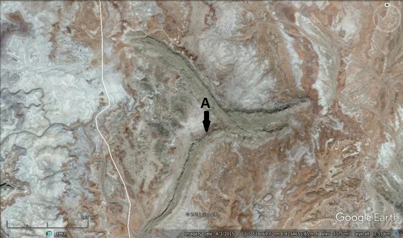
Crossing exhumed and inverted Jurassic palaeochannels near MDRS. “A” and arrow shows the position and viewpoint of Figure 3. Google Earth image.
Crossing channels are also found at several locations at MDRS. While they can be mapped on Google Earth, teir flow direct needs to be confirmed on the ground. Their relative timing is also not always obvious in Google Earth, so this too has to be checked on the ground by determining which is higher and which is lower. On this EVA we checked two such locations north of the station. We parked the rover on the edge of the read and walked to them, a round trip of about 3 km. We were able to determine palaeocurrent directions and timing relationships between all palaeochannels visited. For example Figure 4 shows one palaeochannel as clearly higher in the landscape and thus younger than the lower.

View south from position “A” in Figure 3. Photograph taken from higher and thus younger palaeochannel than the lower one
For me this was one of the most rewarding EVAs of the expedition to date. Not only was there useful science achieved, but we successfully tested a new and useful piece of equipment. Looking forward to collecting the final details on the palaeochannels and further driving in the electric rover.
