

EVA Narrative – October 14th
EVA TO SKYLINE RIM
Jon Clarke
Surface mobility is the key to the exploration of Mars. Here at MDRS most of our mobility is provided by quad bikes, known in this part of the world as ATVs. These are useful, fun and, if misused, dangerous, single seat machines that enable us to cover distances impractical on foot. Here we are restricted to tracks to minimise our environmental footprint but, if not so constrained, we could ride to all but the roughest and steepest areas with them. On Mars there won’t be tracks but, once sites have been driven to, follow-up visits would use the same proven routes. There are no roads on Mars – but there soon will be!

Crossing “White Moon” towards Skyline Rim. Factory Butte (1848 m) rises beyond
Today three of us (Alexandre, Claude-Michell, and I) took our ATVs towards Skyline Rim. This spectacular cliff lies stratigraphically above the area of the station itself. Instead of the familiar red, browns and whites, the geology is dominated by grey tones, the result of weathering of the Cretaceous organic-rich Mancos Shale. The rim itself is composed to the buff-coloured Ferron Sandstone, an ancient delta formed by rivers from the west depositing their sediment load in the Cretaceous seaway. Our interest on this trip was not the Cretaceous sediments themselves, but scouting gypsum locations, to determine the state of the track after several years’ absence, and to ground-truth possible inverted channels indentified on Google Earth.

Looking out across “Grey Moon” and the valley of the Snake River
First we drove north through the familiar red, brown, and purple sediments of the Jurassic Brushy Basin Member than headed west towards Skyline Rim with Factory Butte dominating the skyline. The route took us through an area where the Jurassic sediments were unusually pale in colour, indicating that the iron had been leached out. Perhaps this area had been wetter when the sediments were deposited, and the iron was leached out. The map calls this area “White Moon”. Rising through the stratigraphy, we crossed the Dakota Sandstone, here very thin, which marks the start of the Cretaceous succession. In doing so we entered a visually different world. Instead of the familiar linear ridges and beehive-shaped hillocks of the Brushy Basin, the Cretaceous Mancos Shale landscape consists of dissected low ridges and plateaux of shale varying from weathered (the so-called “Beige Moon” and “Yellow Moon” areas) to almost fresh (the “Grey Moon”). And it is a lunar landscape, saline, mostly devoid of vegetation because of the salinity and the constant shrink-swell of the clay soils during the occasional rains.

Glassy gypsum fragment, about 8 cm across, on the surface.
The gypsum occurs as glassy fragments and sheets, some as much as 20 cm across and 3 cm thick. They glint in the sun like broken glass beside a road. The gypsum forms at the base of the weathering profile. Oxygen-rich water percolating through the shale has weathered the pyrite (iron sulphide) in the organic-rich sediment, forming sulphuric acid. This has reacted with calcium carbonate of fossil shells, forming calcium sulphate brines. These have evaporated leaving behind the clear sheets of gypsum as veins in near surface fractures. The iron from the pyrite precipitates as the yellow iron hydroxide goethite. The shrink-swell behaviour of the weathered shales has heaved the gypsum to the surface. We may well revisit this site later in the mission to sample it for microbes, and compare the results with gypsum formed by sedimentary processes.

The base Skyline Rim – grey Mancos shales capped by yellow Ferron Sandstone
After a short walk up a dry creek to the base of the cliffs (only a 50th the height of those of Vallis Marineris on Mars!) to look at the exposures, we return to MDRS the way we come. We carry out one brief stop at a dried waterfall where a creek has cut through an inverted channel ridge. We noted many features for a future visit – lichens, hypoliths, and overhangs for a geotechnical survey.
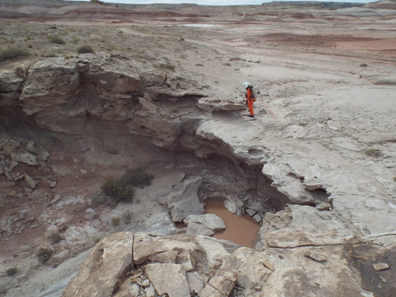
Dry creek and waterfall cutting through an inverted channel ridge
On our three hour EVA we have covered 17 km, almost twice the distance of an Apollo Lunar Rover traverse, in less than half the time. This is not because we work faster than the Apollo astronauts, but because this was a scouting trip. We have the luxury of scouting because we are here for almost 80 days, unlike the Apollo astronauts who had only three days per mission on the Moon and had to deploy geophysical and astronomical stations as well as carry out detailed site descriptions and sampling on their traverses. Astronauts on Mars will likely be there for over 500 days, and they too will be able to scout, selecting the best sites for more detailed study on later EVAs. Despite the distance we have covered, we are never more than 6 km from the station, well within the current NASA estimates of walk back distances on Mars in the unlikely event of all our quad bikes being immobilised. A comforting thought!